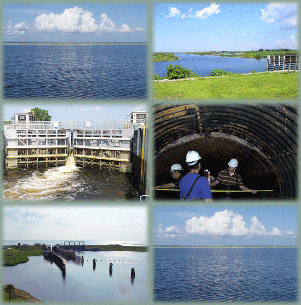
Water Management

Water Management rotating imagesThe Water Management Section monitors and manages the multi-purpose operations of spillways, locks, pump stations, culverts, canals, reservoirs, and water conservation areas located in the Central and Southern Florida (C&SF) Project, the Four River Basins (FRB) Project, and the Portugues and Bucana (P&B) Rivers Project.

NOTE:  South Florida Water Management District (SFWMD) has converted their water level reporting to the new NAVD 88 standard, established in 1993 as the official vertical datum in the National Spatial Reference System for the United States. The U.S. Army Corps of Engineers (USACE) still has additional programming that must be completed before it will be ready to change from NGVD 29 to NAVD 88. Until USACE makes the change, you will see different numbers on the two websites to reference the same measurement.


Our Daily Reports and Graphical Plots show current water level and flow data. Some graphical plots show near realtime data.

The C&SF project is a multi-purpose project that provides flood control; water supply for municipal, industrial, and agricultural uses; prevention of saltwater intrusion; water supply for the Everglades National Park (ENP); and protection of fish and wildlife resources. It involves an area of about 18,000 square miles, which includes all or part of 18 counties in central and southern Florida.

We acknowledge the cooperative efforts of the following federal and state agencies: U.S. Geological Survey, National Weather Service, Everglades National Park Service, South Florida Water Management District, St. Johns River Water Management District and Southwest Florida Water Management District.

View the Okeechobee Waterway Spillway web cameras.

Frequently Asked Questions - Lake Okeechobee Water Management

Collapse All Expand All
 Why aren't you sending more water south to the Everglades?

We remain committed to sending every drop of water south that the state of Florida will allow. USACE does not control the Stormwater Treatment Areas that water must travel through in order to meet court ordered standards required of water entering Everglades National Park. USACE cannot unilaterally send water south to the Water Conservation Areas without it first going through the STAs controlled and operated by the state of Florida. The state has done a phenomenal job of finding ways to move more water south, and we have been honored to partner with them in significantly increasing the water flowing into Everglades National Park and Florida Bay. However, the ability to send water south is limited, and until more projects are built to convey, store, and clean water, regular releases to the northern estuaries will continue to be necessary.

 Why are you using special "coded" language in the Lake Okeechobee System Operating Manual project?

We are using the same language for LOSOM that we use for all of our studies and projects, following the same process we have used for years successfully in multiple projects benefiting South Florida, and have been diligent in responding to questions and concerns from Project Delivery Team members and members of the public throughout this process. There is no secret code or hidden language being used for this project.

 What is a vertical datum? 

A vertical datum is a base measurement point from which all subsequent elevation measurements are determined.

 What is the National Geodetic Vertical Datum of 1929 (NGVD 29)? 

Originally called the Sea Level Datum of 1929, it was established by the National Geodetic Survey and it was the first vertical (elevation) datum for an entire continent in the history of the world. With observations that started in the 19th century, a series of 26 tide gauges were recorded for over 19 years to establish Local Mean Sea Level for all of the coasts of the United States. As technology improved, NGVD 29 was found to have inaccuracies related to currents, wind, temperature, topography of the seabed, barometric pressures, and salinity variations. 

 What is the North American Vertical Datum of 1988 (NAVD 88)? 

The North American Vertical Datum of 1988 was established in 1991. It was created to more accurately reflect elevations across North America. In 1993, the NAVD 88 standard was affirmed as the official vertical datum in the National Spatial Reference System for the United States. A federal mandate requires all government agencies using or producing vertical height information to make the transition to NAVD 88. 

 Why is the SFWMD upgrading to NAVD 88, and when will USACE make the change? 

Technological advancements incorporated into the NAVD 88 standard created the ability for greater accuracy when measuring water levels. NAVD 88 allows for more precision when determining how much water must be moved from one elevation to another. USACE is in the process of preparing to make the change to the NAVD data standard but likely won’t be complete until _________.

 What does the upgrade mean for the public and stakeholders?

The numerical values that are associated with the elevation in lakes, canals and other bodies of water will change on SFWMD’s website, but they will not change yet on the USACE website. Depending on the location within our boundaries, measurements of water levels in NAVD 88 will be approximately 0.6 feet to 1.6 feet lower than they are in NGVD 29. For example, the difference between the two measuring standards in Lake Okeechobee is 1.25 feet, so a water level of 12.5 feet NGVD 29 is 11.25 feet NAVD 88. This variation affects only the numerical value for the elevation point. The volume and depth of water remains the same. While USACE works to make the transition to NAVD, you will see different numbers on the SFWMD and USACE websites.

 Are SFWMD water level gauges calibrated to NAVD 88? 

Yes, all SFWMD staff gauges are now calibrated to the NAVD 88 standard. 

 Will USACE and the District continue to publish data in NGVD 29? 

Once the upgrade is implemented, SFWMD will publish water elevations in NAVD 88. Information for both datum standards (NAVD 88 and NGVD 29) will continue to be available for a period of time on DBHYDRO, the SFWMD’s environmental database for hydrologic, meteorologic, hydrogeologic and water quality data. Data on the USACE website will remain in NGVD until USACE makes the change to the NAVD data standard.

 Why didn't you use the same operational flexibility in 2020 that you used in 2019?

By using operational flexibility, we lowered the lake to 10.79 feet by the start of the dry season in June 2019. This was done to improve lake ecology after several years of high water levels. A relatively dry wet season allowed the lake to reach a low of 11 feet in May 2020 before the start of the rainy season. The difference in the lowest dry season lake level between the two years was 0.21 feet – just over 2.5 inches. 

 Why didn't you release more water during the 2020-2021 dry season?

We maximized our authorities to remove water from the lake before the start of rainy season in 2021, but the near historic rainfalls received at the start of dry season were so significant that they lake remains higher than it had for the past several years. The current dry season started out anything but dry. October 2020saw 174% of normal rainfall. November saw 319% of normal rainfall. December ended 2020 with 113% of normal rainfall.  As the rains began increasing, USACE began long-duration, high-volume releases from October through December, despite urging from many stakeholders to avoid releases completely to the estuaries due to Red Tide and salinity concerns. In January of 2021, with the lake still high, USACE paused releases at the request of stakeholders to provide the estuary with an opportunity to recover from low salinity levels. We began releases again under the approved Harmful Algal Bloom Deviation, allowing us to remove more than 93,000 acre feet of water from the lake that would otherwise still be threatening the estuaries with extended, high volume releases this summer. 

 Why do you release water to the estuaries that has toxins?

We recognize that harmful algal blooms, and the microcystin toxins that can occur from some algal blooms, can be dangerous to humans and animals. We also realize that the economic impact from harmful algal blooms like those experienced during the summers of 2016 and 2018 is significant. That is why we do our best to avoid releases when the risk of toxins on the lake or in the estuaries is high. In fact, the harmful algal bloom deviation approved in Fall of 2020 provides us with another tool to help reduce the potential for long-duration, high-volume releases to the estuaries during the summer months when algal blooms are more likely. However, nature always gets the final vote on when we absolutely must release water. If necessary during hurricane season, we will release water to the estuaries to protect the people living and working near the Herbert Hoover Dike.

 Why don't you treat Lake Okeechobee water to remove algae before estuary releases?

While we have no authority to manage water quality in Florida, we work closely with and support the efforts of state agencies that do have responsibility over water quality issues. The State of Florida is the lead on the much-needed restoration of the water quality in Lake Okeechobee, and we are enthusiastically coordinating with them to support their efforts in that area.

 Why are lobbyists for the sugar industry allowed to write the final plans for the Lake Okeechobee System Operating Manual (LOSOM)?

Several local government stakeholders who are authorized members of the product delivery team (PDT) have hired consultants to assist them as they represent their stakeholder interests on LOSOM. Those consultants did not write any of the the final plans for LOSOM. First, there are no final plans. There are five concepts of balanced plans that we presented May 7, 2021, to the public that include different frameworks that will be modified during modeling to produce the final balanced plans. Second, though all five of the frameworks began as different plans during the conceptual plan and iteration 1 phases, all were modified and combined with other plans that scored well during the initial modeling, so none are authored by any one individual or group.

 Why don't you use the LOSOM plan that your own data shows can eliminate releases to the St. Lucie estuary?

We tested tens of thousands of plans, including several iterations that greatly reduced or even eliminated all releases to the St. Lucie Estuary. During the first phase of testing the single performance measure plans, none of the plans that eliminated all releases to the St. Lucie estuary were able to do so without harming performance in other areas.

 Why are you rushing the decision on the Lake Okeechobee System Operating Manual?

We began the public participation process of LOSOM with scoping meetings that were announced in January 2019, more than two years ago. We started holding regular PDT meetings in August of that same year, and despite having to change our processes for COVID-19, we have succeeded in keeping this study on schedule. We have geared our process to elevate everyone’s understanding of how the system works and reacts, to understand the performance outcomes desired by the various parts of the system, and to understand the key performance metrics that should be used to evaluate performance. The interactions and feedback during the process to this point have been invaluable in the development process. Our task now is to have a system operating manual ready to implement when the Herbert Hoover Dike rehabilitation is complete in 2022, and we are confident that we will be able to meet that timeline.

water management current conditions

Your favorites should be available and you can bookmark the new links!
 

You may need to clear your cache

The Jacksonville District Water Management website recently moved to new servers. Some users may receive an error message that shows the site as unavailable. To view the site, you may need to clear your cache on your browser. The University of Indiana provides this helpful set of instructions for clearing your cache on different browsers, including mobile devices and computers. If you are still having difficulty, contact us for assistance.