Jacksonville, Fla. – The U.S. Army Corps of Engineers asks the public to use extra caution in the waterways and on land features within the Mile Point construction area on the St. Johns River.
The construction zone contains a variety of vessels, including large barges and a dredge with pipelines, in the Chicopit Bay area and Intracoastal Waterway, and crews are also operating heavy equipment at Helen Cooper Floyd Park. These areas are restricted to construction personnel only due public safety concerns.
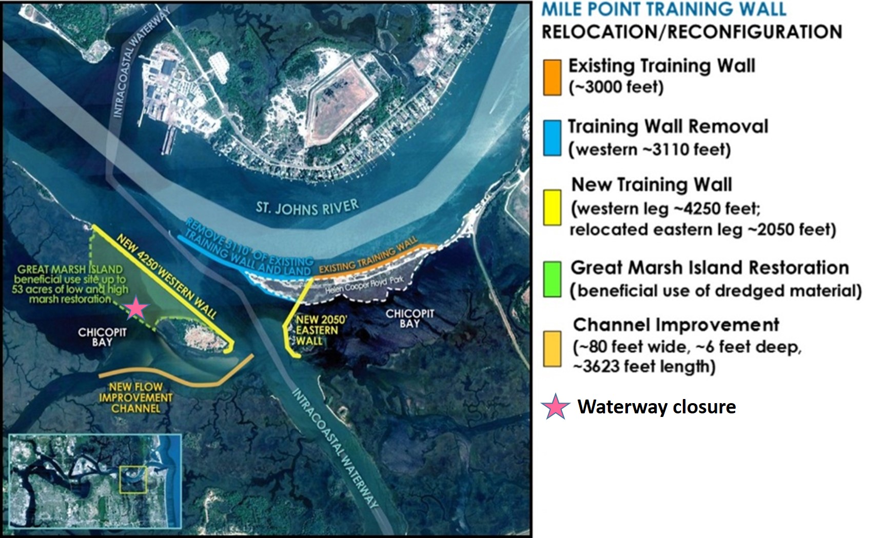
The Mile Point project will improve vessel navigation by rerouting the navigable waters in the Chicopit Bay and the Inter-Coastal Waterway system. Mile Point is where the St. Johns River meets the Intracoastal Waterway, resulting in difficult cross-currents at ebb tide. This restricts port navigation, causing delays and shipping inefficiencies.
The Corps’ contractor for the project, Manson Construction Company, will start dredging a flow improvement channel in Chicopit Bay this weekend. Once complete, crews will cut off an existing navigable waterway (see plan drawing below). Controlled burning will also occur periodically at Helen Cooper Floyd Park throughout April.
Manson crews are using geo-synthetic tubes to build the marsh island perimeter foundation to restore the Great Marsh Island. They’ll place roughly 30,000 tons of stone to construct the western training wall, and then fill in the interior with dredged material. To date, Manson has placed 20,000 tons of stone, 675 marine mattresses and 239 precast units for the west leg training wall.
The Mile Point project will result in the loss of 8.15 acres of salt marsh at Helen Cooper Floyd Park, which will be offset by restoring 18.84 acres of salt marsh at Great Marsh Island. Beyond the mitigation requirement, the Corps is using dredged material from the project to restore up to a total of 53 acres of salt marsh at the island. This effort includes restoration of high and low salt marsh as well as low dune and oyster habitat, which is an excellent fish environment. The new west leg training wall should also substantially reduce active erosion at Great Marsh Island.
Additional work at the site includes marine animal monitoring, bird monitoring, turbidity monitoring, and coordinating with U.S Coast Guard officials. The Coast Guard will remove and reinstall three aid-to-navigation structures. Temporary navigation devices, such as buoys and signs, currently mark the area.
In upcoming months, contractors will relocate approximately 3,300 feet of stone from the existing training wall at the park and build a training wall on the southeast side along the Intracoastal Waterway. Manson will use all satisfactory stone material recovered from the existing training wall to construct the new training wall.
The Corps asks the public to respect the construction zone restrictions and to remain vigilant in the waterways. Safety, as always, is the number one priority on this project.
For a navigation emergency, please contact the U.S. Coast Guard at 904-564-7513. All navigation notices are posted on the Coast Guard Region 7 webpage at http://www.navcen.uscg.gov/?pageName=lnmDistrict®ion=7. Mariners can also register for emailed local navigation notices on this website.
The Corps estimates construction will continue through November 2016.