May 2025
FACT SHEET
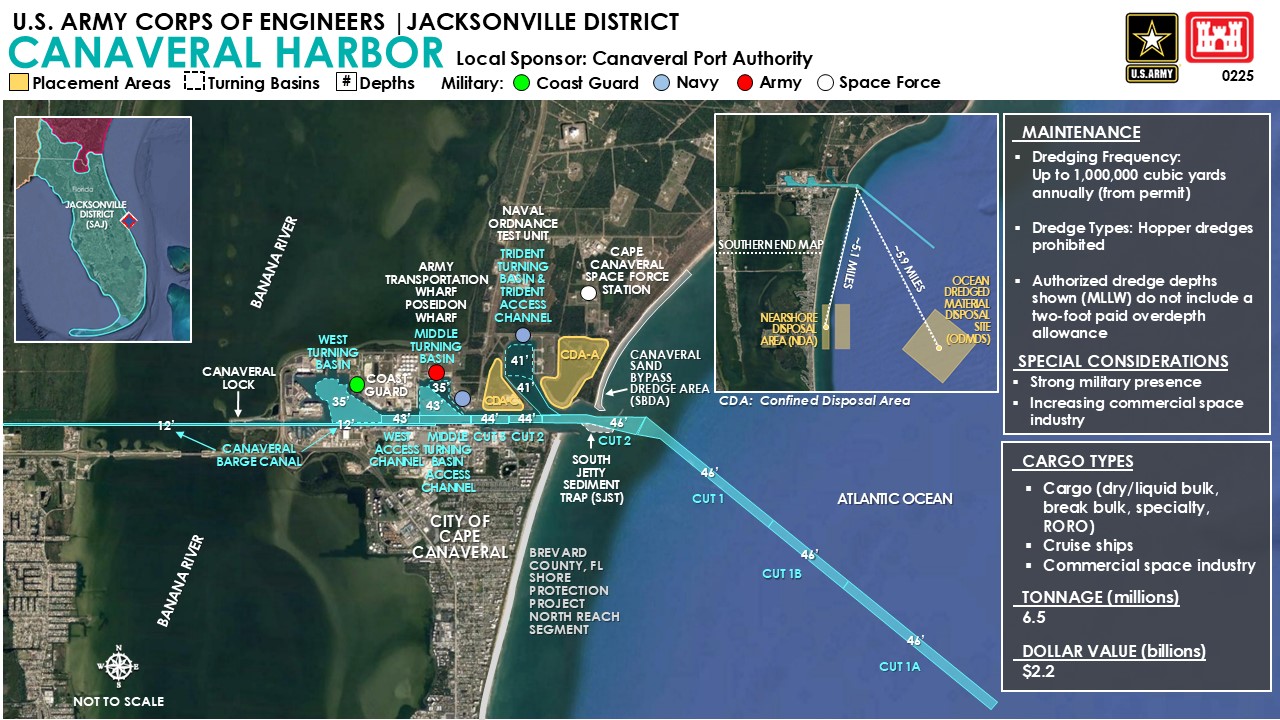
Canaveral Harbor, FL
Operations and Maintenance (O&M)
Congressional District: 8
1. DESCRIPTION
The Water Resources Reform & Development Act (WRRDA) of 2014 authorized new Canaveral Harbor improvements, including widening of the main ship channel from the harbor entrance inland to the West Turning Basin and West Access Channel from its current authorized width of 400 feet to 500 feet, deepening the Outer Reach, Cut 1A from -44 feet to -46 feet for a length of 11,000 feet, deepening the Outer Reach, Cut 1B from -44 feet to -46 feet depth for a length of 5,500 feet; deepening the Outer Reach, Cut 1 from -44 feet to -46 feet for the 5,300 feet long portion of Cut 1 that is seaward of buoys 7/8 (Station 0+00 to Station 53+00), deepening the remainder of Cut 1 from buoys 7/8 to the apex of the channel turn, a length of 7,200 feet from -44 feet to -46 feet; a new 203 Turn Widener -46 feet deep X 23.1 acres (irregular shaped area) bounded to the north and northeast by the Civil Turn Widener and Outer Reach, Cut 1, deepening the U.S. Navy Turn Widener from -44 feet to -46 feet X 7.7 acres (triangular shaped area) bounded by outer and middle reaches to the north and northeast and the Civil Turn Widener to the southwest; deepening the Civil Turn Widener from -41 feet to -46 feet X 15.6 acres (irregular shaped area) bounded to the north and northeast by the middle reach and the U.S. Navy Turn Widener, deepening the Middle Reach from -44 feet to -46 feet for a length of 5,658 feet; deepening the Inner Reach, Cut 2 and Cut 3 from -40 feet to -44 feet for a length of 3,344 feet, deepening and expanding the Middle Turning Basin to encompass 68.9 acres to a project depth of -43 feet and a turning circle diameter of 1,422 feet, deepening the West Access Channel (east of Station 260+00) from -39 feet to -43 feet for a length of 1,840 feet, expanding the West Turning Basin and West Access Channel (west of Station 260+00), and expanding the turning circle diameter from 1,400 feet to 1,725 feet X 141 acres at a depth of -35 feet. In addition, the original authorization included a barge canal 125 feet wide and -12 feet deep, a lock 90 feet wide and 600 feet long west of the harbor dike, and two entrance jetties to the 12-foot contour. The total length of the project is approximately 15 miles excluding turning basins.
2. FUNDING
a. P.L. 115-123: Bi-Partisan Budget Act of 2018, Supplemental:
| Current Working Estimate |
$4,500,000 |
| Allocation thru FY24 |
$4,500,000 |
| Allocation for FY25 |
$0 |
b. P.L. 117-58: Infrastructure Investment and Jobs Act:
| Total Work Plan |
$15,000,000 |
| Allocation thru FY24 |
$15,000,000 |
| Allocation for FY25 |
$0 |
c. P.L. 117-43: Disaster Relief Supplemental Appropriations Act:
| Total Work Plan |
$10,000,000 |
| Allocation thru FY24 |
$10,000,000 |
| Allocation for FY25 |
$0 |
d. P.L. 117-328A: Division N 2023 Disaster Relief Supplemental Aappropriations Act:
| Current Working Estimate |
$14,000,000 |
| Allocation thru FY24 |
$14,000,000 |
| Allocation for FY25 |
$0 |
3. SPONSOR
Canaveral Port Authority
P.O. Box 267
Cape Canaveral, Florida 32920
4. STATUS
The last O&M dredging contract combining the Canaveral Harbor civil works project and the Canaveral Naval Ordnance Test Unit (NOTU) U.S. Navy project was completed in September 2023, having removed 1,589,865 cubic yards of shoaled material from the federal and military channels. The current dredging contract, also combining the civil works project and the NOTU projects, was awarded in February 2025 utilizing a combination of Bipartisan Infrastructure Law funding, Regular funding, and Navy funding to remove an estimated 1,151,000 cubic yards of shoaled material. FY25 funds will additionally be used for operations and maintenance of Canaveral Lock with $2.85M in specific work funding to continue the Lock Eastern Sector Gate replacement project.