Revised Draft Supplemental Environmental Impact Statement for Port Everglades Harbor
The U.S. Army Corps of Engineers conducted two public, virtual presentations March 8, 2022, of its Revised Draft Supplemental Environmental Impact Statement (RDSEIS) for the Port Everglades Harbor Improvements project, which was originally published Feb. 4, 2022, for public review and comment.
Click on the link below to review the presentation slides.
https://usace.contentdm.oclc.org/utils/getfile/collection/p16021coll11/id/5519
The authorized plan for the Port Everglades, Florida, project consists of deepening and widening various components within Port Everglades Harbor to increase navigational safety and efficiency, and includes a reconfiguration of the U.S. Coast Guard Station Fort Lauderdale.
The RDSEIS and supporting documentation are available on the district website at https://www.saj.usace.army.mil/About/Divisions-Offices/Planning/Environmental-Branch/Environmental-Documents/. Scroll down to Broward County and click on the [+] to open another page. Then scroll down to the bottom of the list to find Port Everglades Harbor, Revised Draft Supplemental Environmental Impact Statement.
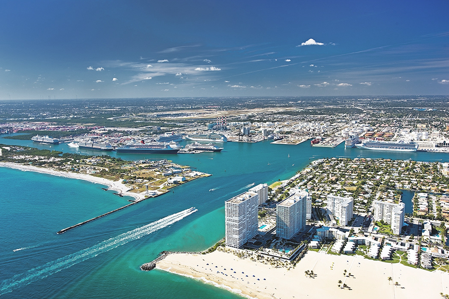
Port Everglades is located in the heart of greater Fort Lauderdale and the City of Hollywood, Florida. It’s a manmade harbor first Federally authorized in 1930. The Broward County Port Authority, established in 1927 by the Florida State Legislature, requested that the United States construct the outer breakwaters and assume the maintenance of the breakwaters, jetties, channels and basins outside the pier-head lines. In the decades since, Port Everglades has become a significant economic force in Florida and the Nation. It is South Florida’s main seaport for receiving petroleum products; a leading container port that ranks 12th in the nation in terms of total tonnage; and, is one of the top three cruise ports worldwide (2013 data). In addition, Port Everglades serves the nation as a military port, home to both the U.S. Coast Guard and the U.S. Navy.
Port Everglades is an important key node for European and South American trade routes. The port is strategically located with access to a multi-modal transportation network, including the Atlantic Ocean shipping lanes, the Florida East Coast railway, Florida's highway system, and the Fort Lauderdale-Hollywood International Airport.
The configuration of the current Federal project dates back to the 1980s, making it difficult to accommodate today’s larger container and tanker vessels. Navigation is further challenged by strong and unpredictable cross currents in or near the outer entrance channel. These currents can exceed 5 knots at times, and change by the hour. Vessels have been held at sea for hours to days until currents sufficiently subside to ensure safe passage.
Navigation in the port is challenged by insufficient channel depths and widths. With navigation improvements there is an opportunity to reduce transportation costs and bring forecasted volume of goods into the harbor on fewer, larger and more efficient ships.
The Port Everglades Harbor Feasibility Study was initiated in 1997 with the non-Federal sponsor, Broward County. The primary purpose of conducting the study was to investigate improvements to the Federal navigation project. The overall goal was to decrease costs associated with vessel delays from congestion, channel restrictions and berth deficiencies.
The existing Federal Channel project depth of 42-feet does not provide adequate, safe depth for large tankers and container ships currently visiting the harbor. The next generation of container ships and oil tankers requires significantly more channel depth to operate efficiently.
The study accommodates existing and future vessel movements, resolves navigation restriction problems, and presents opportunities for national economic development. Since release of the draft feasibility study in June 2013, the Corps has pursued consultation with responsible state and federal agencies regarding revised endangered species coral listings, and refining mitigation and monitoring plans.