June 2021
FACT SHEET
Herbert Hoover Dike, FL
Construction (C)
Congressional Districts: 17, 18, 20, 21, 22, 25
1. DESCRIPTION
AUTHORIZATION: The Rivers and Harbors Act of 1930 provided for improvements to the Caloosahatchee River and Lake Okeechobee drainage areas in accordance with Senate Document Number 115, 71st Congress, 2nd Session. The Act required the United States to construct all the levees around Lake Okeechobee to be built (original 67.8 miles of southern levee and 15.8 mile of northern levee).
The Rivers and Harbors Act of 1935 modified the 1930 Act to require that the United States to operate and maintain the Project works authorized by the 1930 Act and to bear the cost of all drainage structures constructed in connection with the project. USACE became responsible for construction, operation and maintenance of 16 drainage culverts and 5 hurricane gate structures and the 67.8 miles of the southern levee and 15.8 mile of the northern levee.
The Flood Control Act of 1948 authorized Phase 1 of the Central and Southern Florida (C&SF) Project which included construction of the remainder of the levees around Lake Okeechobee and raising the existing levees constructed pursuant to the 1930 Act. The Act provided: “CENTRAL AND SOUTHERN FLORIDA-The project for Caloosahatchee River and Lake Okeechobee drainage areas, Florida, authorized by the River and Harbor Act of July 3, 1930, as amended, is hereby modified and expanded to include the first phase of the comprehensive plan for flood control and other purposes in central and southern Florida as recommended in House Document No. 643, 80th Congress.” The levees around Lake Okeechobee became part of the Central and Southern (C&SF) Project for Flood Control and other Purposes.
The Flood Control Act of 1960 authorized the name of all levees around the shore of Lake Okeechobee to be “Herbert Hoover Dike”, in honor of the former president.
The Flood Control Act of 1968 further modified the C&SF Project in accordance with House Document 369, 90th Congress. HD 369, 90th Congress, authorized raising HHD levees (4 feet) and modifications to water control structures. (Note: not all these modifications were constructed.).
Other portions of the C&SF project were authorized in the Flood Control Acts of 1948, 1954, 1960, 1965, and 1968; in 1970 under Section 201 of the Flood Control Act of 1965; and the Water Resources Development Acts (WRDA) of 1986, 1988, 1990, 1992, 1996 and 2007.
BACKGROUND: The HHD system consists of approximately 143 miles of levee surrounding Lake Okeechobee, with 32 culverts, hurricane gates and other water control structures. The first embankments around Lake Okeechobee were constructed by local interests from sand and muck circa 1915. Hurricane tides overtopped the original embankments in 1926 and 1928, causing over 3,000 deaths. The Rivers and Harbors Act of 1930 authorized the construction of 67.8 miles of levee along the south shore of Lake Okeechobee and 15.7 miles of levee along the north shore. The U. S. Army Corps of Engineers (Corps) constructed the levees between 1932 and 1938 with crest heights ranging from +32 to +35 feet, National Geodetic Vertical Datum (NGVD).
A major hurricane in 1947 prompted the need for additional flood protection work. As a result, Congress passed the Flood Control Act of 1948, authorizing the first phase of the C&SF project, a comprehensive plan to provide flood protection and other water control benefits in central and south Florida. By the late 1960s, the new dike system was completed, raising the elevation of the levees to a maximum +41 feet, NGVD. This provides protection to the Standard Project Flood (SPF) level, an event occurring approximately once in 935 years.
However, investigations into the dike system's potential seepage and stability problems conducted in the 1980s and early 1990s identified two major areas of concern: the seepage and embankment stability at the culvert locations, and the problematic foundation conditions of the dike. During high-water events, piping is experienced through the embankment. In 1999, the Corps developed a plan to rehabilitate the HHD. The plan, approved in 2000, divided the 143-mile embankment into eight reaches with the initial focus on Reach 1. In August 2016, the Corps Dam Safety Officer approved the Dam Safety Modification Report (DSMR), which includes all remaining fixes to bring HHD within tolerable risk guidelines.
2. FUNDING
a. Regular Civil Works Funds:
| Estimated Total Cost |
$1,835,300,000 |
| Estimated Federal Cost |
$1,835,300,000 |
| Allocation thru FY20 |
$1,835,300,000 |
| Allocation for FY21 |
$0 |
| President's Budget FY22 |
$0 |
b. P.L. 115-123: Bi-Partisan Budget Act of 2018, Supplemental:
| Current Working Estimate |
$514,200,000 |
| Allocation thru FY20 |
$320,884,000 |
| Allocation for FY21 |
$0 |
3. SPONSOR
South Florida Water Management District (SFWMD)
3301 Gun Club Road
West Palm Beach, Florida 33416-4680
4. STATUS
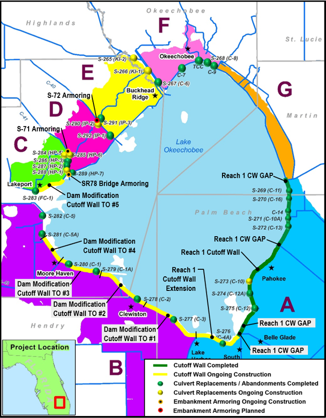
FY2019 allocations are being used to complete construction on the remaining seven water control structure replacements and the Reach 1 Cutoff Wall Extension contract. All water control structure replacement contracts are currently on schedule for completion in 2021.
$100 million in Section 1024 Contributed Funds from the State of Florida are being used on the Reach 1 Cutoff Wall Extension contract ($50 million) and the Cutoff Wall MATOC Task Order #1 contract ($50 million).
The Long-term Disaster Relief Investment Program (LDRIP) funds are being used on the 5 cutoff wall contracts in construction and the State Road 78 Bridge & S-71 Embankment Armoring contract. The final risk reduction contract (S-72 Embankment Armoring) is scheduled for construction award in July 2021. All cutoff wall and armoring construction contracts are currently on schedule for completion in 2022.
