May 2023
FACT SHEET
Turpentine Run, VI
Construction (C)
Congressional District: U.S. Virgin Islands
1. DESCRIPTION
The Turpentine Run project is a flood risk management project that was originally authorized under the Continuing Authorities Program (CAP) Section 205 and approved by the U.S. Army Corps of Engineers (USACE) in 1994, but the project was not awarded. The project is now being planned under the authority of Section 209 of the Flood Control Act of 1966 which authorizes studies for flood control in the United States and its territories, and Title IV, Division B of the Bipartisan Budget Act of 2018, Public Law 115-123, enacted February 9, 2018 (BBA18), which authorized the Government to conduct a study at full federal expense. As a result, a CAP Conversion Feasibility report was completed in March 2020, and a Chief’s Report was signed in August 2020 recommending that the project moves forward for Congressional Authorization. The project was authorized for construction under Section 401(2)(13) of the Water Resources Development Act (WRDA) of 2020 which allows it to move directly into Pre-Construction Engineering and Design (PED).
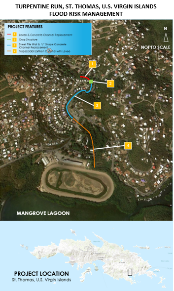
The Turpentine Run area is located about four miles southeast of the city of Charlotte Amalie, on the southeastern end of the island of St. Thomas, U.S. Virgin Islands. Adjacent to the Nadir residential area, there is an existing concrete channel, which carries Turpentine Run past the developed area. The capacity of this channel is insufficient to carry flood flows thereby causing flooding in the development. In addition to monetary damage, the nature of the flooding creates a substantial and significant threat to the safety of area residents. The recommended plan involves replacement of the existing concrete channel with a new channel having greater capacity. Beginning at the north end of the Nadir development and ending at a discharge point into Mangrove Lagoon, the project’s principal improvements would include a 260-foot levee constructed along the northern edge of the development, a 170-foot sheet pile wall constructed along the developed western side of the channel, a 60-foot drop structure, a 460-foot “U” shaped concrete channel that transitions to a 1,385-foot trapezoidal, an earthen channel lined with rip rap, a 1,300-foot levee south of the new Bovoni Road Bridge ending at the Nadir racetrack, and an interior drainage system, including 1,745 feet of pipe, to convey water from the small existing channel to Mangrove Lagoon. Where possible, the existing concrete channel wall along the Nadir development will be left intact. The local sponsor replaced the existing Bovoni Road Bridge.
2. FUNDING
| Estimated Total Cost |
$48,100,000 |
| Estimated Federal Cost |
$32,000,000 |
a. P.L. 115-123: Bi-Partisan Budget Act of 2018, Supplemental:
| Current Working Estimate |
$400,000 |
| Allocation thru FY22 |
$400,000 |
| Allocation for FY23 |
$0 |
| |
|
b. P.L. 117-43: Disaster Relief Supplemental Appropriations Act:
| Total Work Plan |
$48,100,000 |
| Allocation for FY23 |
$31,722,000 |
3. SPONSOR
U.S. Virgin Islands Department of Public Works
8244 Sub Base
Charlotte Amalie, U.S. Virgin Islands 00802
4. STATUS
The Chief’s Report and Environmental Assessment were signed on August 17, 2020. Congress authorized the project with a total project cost of $45,129,000 ($29,817,850 Federal) under Section 401 of WRDA 2020.
A Construction New Start to initiate the construction phase was granted and federal cost share was fully funded under Disaster Relief Supplemental Appropriations Act (DRSAA). An initial $100,000 of funds were allocated to the Project Delivery Team (PDT) to prepare the Project Management Plan and Review Plan and execute the Design Agreement (DA) with the sponsor. The Project Management Plan was completed in February 2023, the Review Plan was completed in April 2023, and the DA was executed on March 20, 2023.