April 2022
FACT SHEET
COMPREHENSIVE EVERGLADES RESTORATION PLAN
Lake Okeechobee Watershed Restoration Project
Construction (C)
Congressional Districts: 17, 18, 19, 20, 21, 22, 23, 24, 25
1. DESCRIPTION
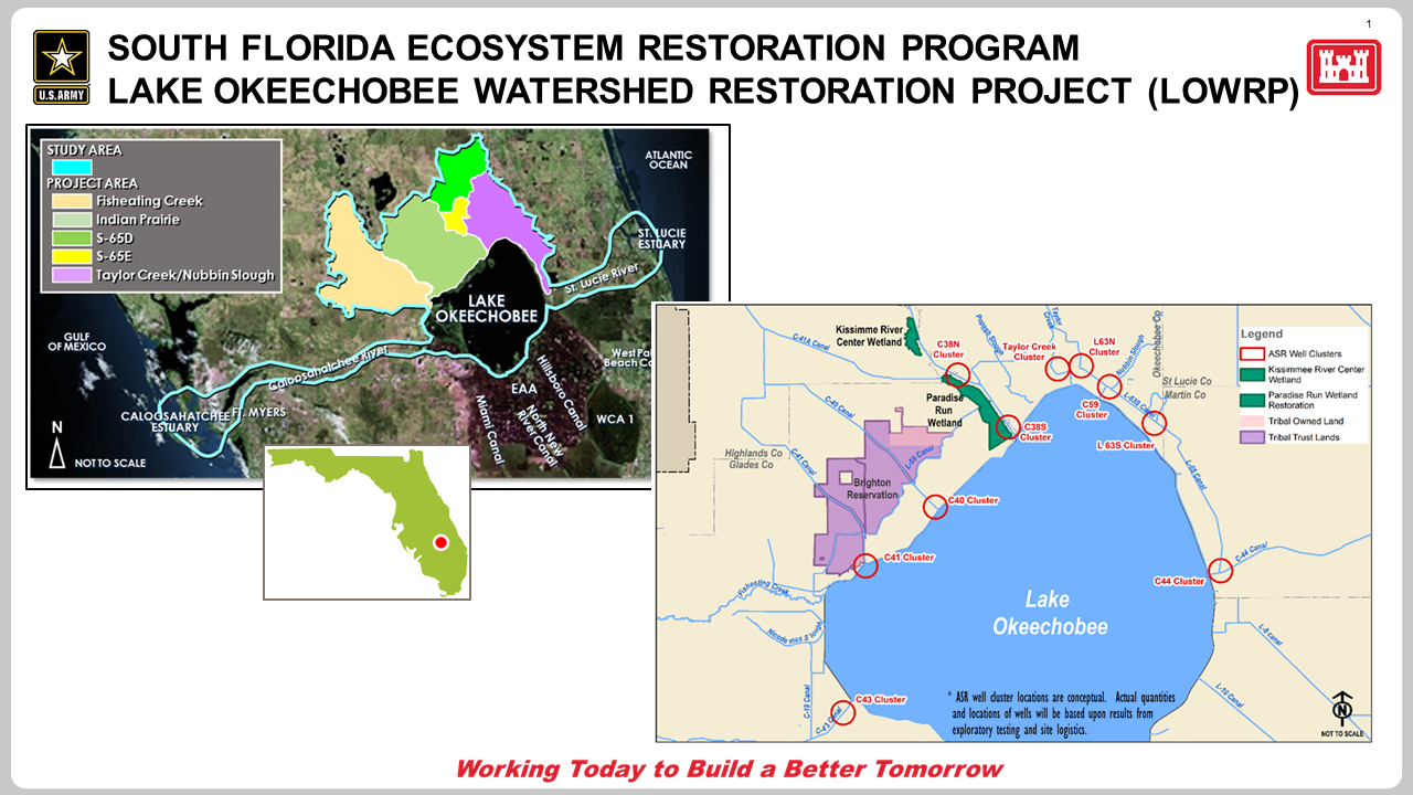
Congress authorized the Comprehensive Everglades Restoration Plan (CERP) in the Water Resources Development Act (WRDA) of 2000, Section 601 (b)(1)(A), as the framework for restoration of the south Florida ecosystem. The Lake Okeechobee Watershed Restoration Project (LOWRP) is composed of components of the overall CERP plan north of Lake Okeechobee. LOWRP’s primary objectives are to capture, store, and redistribute water entering the northern part of Lake Okeechobee to improve lake stage levels; improve discharges to the Caloosahatchee and St. Lucie estuaries; restore/create wetland habitats; re-establish connections among natural areas that have become spatially and/or hydrologically fragmented; and increase available water supply.
The Lake Okeechobee Watershed is located mainly to the north of Lake Okeechobee. As defined hydrologically, the watershed is approximately 8,687 square miles, almost 13 times the area of the lake itself; the study area encompasses approximately 1,500 square miles of the overall watershed. The watershed’s primary sub-watersheds are the Kissimmee River Basin, Lake Istokpoga Basin, Indian Prairie Basin, Taylor Creek/Nubbin Slough Basin and the Fisheating Creek Basin. The contributing sub-basins discharge water into Lake Okeechobee; from there water is then discharged to the east through the St. Lucie Canal (C-44) into the St. Lucie Estuary, to the west through the Caloosahatchee River (C-43) into the Caloosahatchee Estuary, and to the south through four major canals in the Everglades Agricultural Area (EAA) into the Water Conservation Areas (WCA).
Bounded by the sand hills of the Lake Wales Ridge on the west and upland forest and marshes of the Osceola Plain to the east, the Lake Okeechobee watershed is a shallow trough that drains south from Orlando to Lake Okeechobee. This is a diverse ecosystem that includes thirteen major vegetation community types: mesic temperate hammock, mesic pine flatwoods, hydric pine flatwoods, grasslands, wet prairie, freshwater marsh, seepage swamp, flowing water swamp, pond swamp, open water, scrub, scrubby high pine, and scrubby flatwoods. It is home to no less than 26 species of wildlife and 41 species of plants that are listed by federal and/or state agencies as threatened or endangered species.
Implementation of new and restored environmental infrastructure—including wetland restoration and aquifer storage and recovery (ASR) wells—will allow us to realize these project benefits:
- Improvement to the quantity, timing and distribution of flows into Lake Okeechobee to maintain ecologically desired lake stage ranges.
- Improvement in the salinity regime and the quality of oyster, submerged aquatic vegetation, and other estuarine community habitats by limiting damaging freshwater discharges to the Northern Estuaries.
- An increase in the spatial extent and functionality of wetland habitat throughout the Lake Okeechobee watershed.
- An increase in available water supply for existing legal users of Lake Okeechobee.
2. FUNDING
| Estimated Total Cost |
$8,000,000 |
| Estimated Federal Cost |
$5,800,000 |
| Allocation thru FY21 |
$5,111,000 |
| Allocation for FY22 |
$0 |
| President’s Budget FY23 |
$0 |
3. SPONSOR
South Florida Water Management District (SFWMD)
3301 Gun Club Road
West Palm Beach, Florida 33406
4. STATUS
The Project Delivery Team began development of a Project Implementation Report (PIR) and Environmental Impact Statement (EIS) under the requirements of the U.S. Army Corps of Engineers SMART (Specific, Measurable, Attainable, Risk-informed, Timely) planning process in July 2016. After the release and review of the LOWRP Final PIR/EIS in August 2020 and the LOWRP Draft Report of the Chief of Engineers dated October 2020, the USACE determined a revision to the documented Recommended Plan, Alternative 1BWR, was warranted. Concerns brought forward about Alternative 1BWR were related to the acceptability of aboveground storage sited directly upstream from a community and adjacent to the Seminole Tribe of Florida Brighton Reservation, and the high cost per acre-foot of shallow aboveground storage. The concerns were addressed by removing the shallow storage WAF and its 25 WAF-assisted ASR wells from the plan, creating a revised Recommended Plan called Alternative ASR. The team received approval of a third exemption to the SMART planning 3x3x3 requirements in September 2021 providing approval to complete the Chief’s Report by July 2022, in time for consideration for authorization in a potential WRDA 2022. Through integration of ASR wells and wetland restoration features, the Recommended Plan improves operational flexibility in Lake Okeechobee to address high-volume flows to the Northern Estuaries, long-term lake health, and water supply for the environmental and human systems. The removal of shallow aboveground storage reduces the overall system flexibility but could be considered in future CERP storage efforts.
